Summary
- Coral Monitoring: Start date 21st April 2015; Duration: 20 weeks
- Dredging: Start date 29th April 2015; Duration: 19 weeks
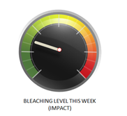
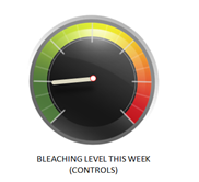
- The dials are status on 8th September 2015 with an average of 24% bleaching at Impact sites and 16% bleaching at Control sites
- Dredging Locations: Dredge worked off Fogafale adjacent to:
- Borrow Pit 2 – 29 April-7 July
- Borrow Pit 4 – 7-13 July
- Borrow Pit 7 – 13th July-17 August (including trucking of fill to BP 6 and BP 9)
- Borrow Pit 1 – since 22nd August.
- Monitoring at all sites continues on Tuesdays and Thursdays each week
- Coral bleaching continues to be below trigger levels (50% bleaching C1-C5 averaged over all corals), though levels continue to increase slowly at all sites.
- No action is required.
Results 7th August – 8th September
The dredge is now working in the area adjacent to Borrow Pit 1 (BP1), south of the runway at Kavatoetoe. The area being disturbed is wholly within the eutrophication zone with low numbers of live corals. Several weeks have passed since the last bulletin and the impact sites are now considered to be at 3 Catalina Patch and 4 South End which are closest to the dredge. 1 North End and 2 Tegako Jetty are now considered the (relative) controls.
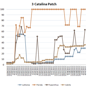
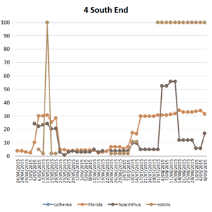
In the dials above levels of bleaching are higher at impact than at control sites (24% versus 16%). Most of this difference has been driven by a high level of bleaching found at 3 Catalina Patch since the start of the project. Despite that background bleaching, there were signs of increasing bleaching at all sites over the past month.
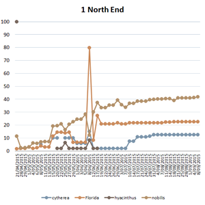
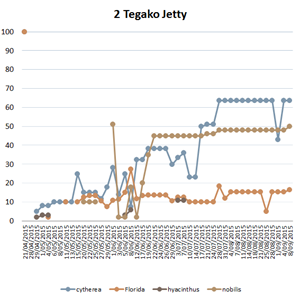
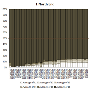
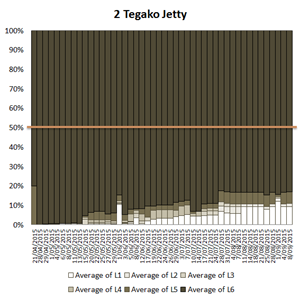
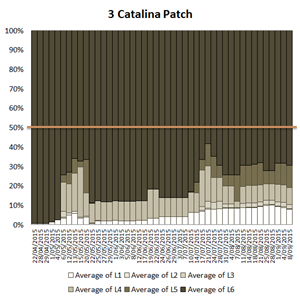
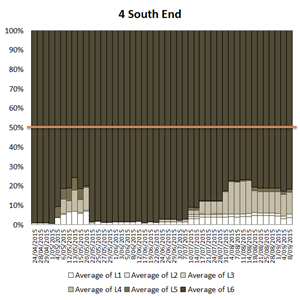
Figure 1 shows that bleaching increased at all sites, and that this involved all of the species of corals. The greatest increases were noted in all sites from 2 Tegako Jetty to 4 South End, with only minor increases at 1 North End. This increase is indeed likely to be attributable to the dredging, with most of the change following the southern movements of the dredge itself. Figure 2 shows that Site 3 Catalina Patch continues to show the highest levels of bleaching of those being monitored. It also shows significant increases at Site 4 South End after the dredge shifted south to BP4, which continued to increase as the dredge moved to areas adjacent to BP7 and BP1. It is highly likely that these changes in levels of bleaching can be attributed to dredging.
Conclusions
All of the indicator graphs show that the level of bleaching is continuing to increase at all sites, but most slowly at 1 North End which has been furthest from any dredging activity since early July (2 months). The data are suggesting that BOTH external factor(s) are causing bleaching that is unrelated to dredging (e.g. the low mid-year tide levels and El Nino effects), AND that there is an impact of dredging. Despite the observed changes in coral health, overall average levels of bleaching remain below trigger levels and the prognosis that dredging will be able to complete without widespread detrimental effects seems likely.
Figure 1: Levels of bleaching by species and site

Figure 2: Average percentage of all coral surfaces in each level of bleaching (C1-5) and unbleached (C6) at each of the 4 sites. At this time Sites 3 and 4 (Catalina Patch and South End) are closest to the dredging and considered impact sites. Sites 1 and 2 are considered controls. The line shows the 50% trigger.

