 Building harbours on atolls is problematic at best. Atolls are ‘living’ structures, 100% made from the skeletons of once living things (not counting the volcanic core buried far beneath them). They need to be unconstrained to grow, or at least maintain, their current structures, especially their islands. To keep in shape, rubble and sand needs to be constantly manufactured on the reefs and inside the lagoon, and the action of wind, currents and waves needs to be able to deliver that material up on beaches, banks and islets (see an earlier post here).
Then people come along and want to modify them so they can have infrastructure for living. Fair enough. People need housing, roads, airports and sea ports, among very many other things for a decent chance to develop. On atolls the worst of these are the ports and harbours because they are placed on the most dynamic parts of islands.
The problem arises because where islands are inherently flexible, engineering is all about freezing things (built structures) in one place.
3 Natural Factors that make Atolls bad for Harbours
The need to ‘feed’
Rocky ‘high’ islands and continents are less dependent on currents, winds and waves bringing sand and gravel together to form islands on a daily basis and/or during storms. High islands and continents are mostly large enough to be less worrisome and are usually comprised of inorganically-sourced materials or raised palaeo-reefs that are in the process of eroding. On atolls with ‘living’ islands, the supply of sediments is a life-and-death issue. Cut off the sand supply and an island can wash away in record time.
The need to move
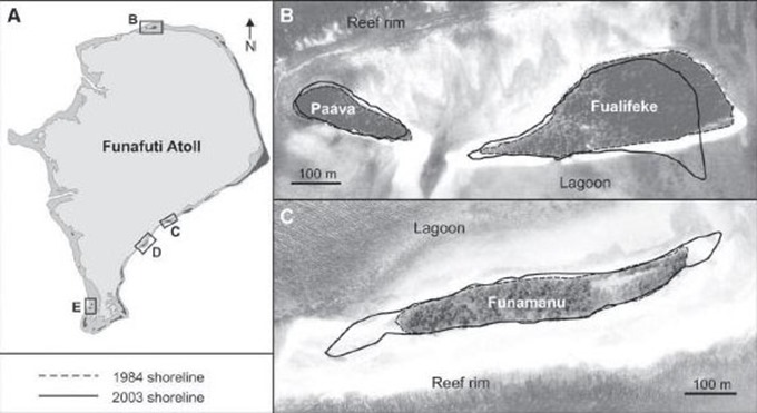
To make matters worse, islands can grow, shrink and move around in response to seemingly invisible changes in the weather and wave climate. Sometimes the ends of islands can shift around so much that over decades a spit can resemble the wagging tail on a dog. The picture below shows how some of the islets in Funafuti changed over a 19 year period. Building permanent structures that depend on the exact location of these shorelines is futile.
Image: Changes in reef island planform characteristics 1984–2003 for selected study islands Funafuti atoll, Tuvalu (from Webb & Kench 2010).
A further complication: Ponding Lagoons
 If these challenges were not difficult enough, there is a third problem that turns up some of the time. Atolls can also have a ponding lagoon. This means that the reef platform is high enough to hold the water level inside the lagoon above low tide level outside. Water does leak out in places, but the rate of leakage is relatively slow and prevents the lagoon from reaching the same level as the outside ocean over the time of a tidal cycle.
Any engineering that breaks through that atoll wall to give access to boats from the outside ocean creates a cascade of water pouring out of the hole whenever the tide level is lower than the rim. This lowers the level of the lagoon, damages the lagoon ecosystems, kills corals and makes navigation by boats very difficult.
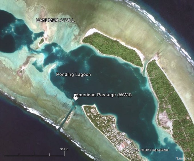
Nanumea Atoll, Tuvalu, has at least 2 ponding lagoons, both of which retain a higher water level than the outside ocean during low tides. One of these had a channel blasted through it during World War II to build the ‘American Passage’. These days the main south-east lagoon (pictured below) is some 30-40 cm above the ocean, while a smaller lagoon to the north-west is probably about 15 cm higher than the main lagoon. The hole punched into the main lagoon would have caused major impacts, lowering the original low tide water level by as much as 0.5m and killing corals (their skeletons are easily seen all around the shallow margins). Creating the passage also set up strong currents of 1-1.5 metres per second resulting in the channel being difficult to navigate during outgoing tides. Pre-WWII tidal exchange would have occurred only during the top half of the tide, and that would have been spread more-or-less evenly over the entire reef crest so that no focused large currents would have been seen. The losses of fisheries productivity, corals and diversity would have been significant.
In Tuvalu ponding lagoons (including fringing lagoon areas) are also found on Nukulaelae, Nui, Niulakita, Vaitupu and Nukufetau.
Image: Part of Nanumea Atoll, showing ponding lagoons, main settlement and American Passage (Google Earth).
Damage Caused by “Big Country” Harbours
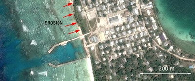 Traditional harbours, developed in continental countries and which are attached to the shoreline (like this one in Vaitupu, Tuvalu) cause many problems. These kinds of harbours do not acknowledge the unique characteristics of atolls. They interrupt normal sediment movements and prevent islands from maintaining the sand supply so needed to avoid erosion. In this picture, erosion to the north of the harbour is severe and runs along the length of the island, while to the south sand is piling up, unable to get past the harbour structure that has been attached to the shoreline.
Clearly, we need another way of solving the transport problems, without inflicting serious damage to the stability of our ‘living islands’.
The Satellite Harbour Concept
A satellite harbour would address most of the problems.
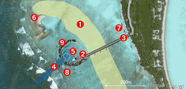
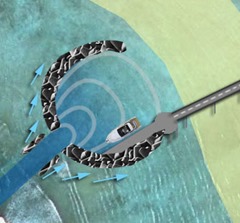
The idea is to construct a harbour offshore that could either be left as such (freestanding), or be connected by a bridge to the shore, allowing people to use vehicles to access it. The general idea is to create a harbour that does not destabilise the islands, does not cut into the ponding lagoon, does not affect normal sand movements at the beach (much) which maintain the land, and which mimics the natural mechanisms used on atolls to dissipate wave energy. Read on for all the parts as highlighted in the image of Nukulaelae (Tuvalu) below:
1. Ponding lagoon wall: This is a higher area between the existing channel and the island. It forms a partial swimming pool wall that prevents the tide escaping all the way out of the lagoon. The sea level height inside the lagoon is higher than the ocean at low tide, making Nukulaelae’s lagoon truly ponding. A small channel cut into the reef at (4) was purposely left short and fully on the seaward side of the lagoon wall by a New Zealand project (Ship-to-Shore Project 2012) because they understood the huge risks involved. That is why the channel remains so far away from the beach. Although bringing small boats past the breakers was and still is a help to the residents of the island, there is no easy way to get cargo and passengers all the way to the land.
2. Wharf face: This is tucked into the satellite harbour breakwater wall in the area of protected waters created by the harbour walls themselves. This allows ships to have a quicker turn-around (saving costs since time taken unloading = money), giving cargo-handlers a place to unload the cargo for later carriage to the shore.
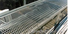 3. Jetty: This is a piled structure (like a bridge) that allows people to access the satellite harbour. This could be built of pre-cast concrete decking placed on a piled structure that can allow for large vehicles, but this option could be expensive. Other options could include the use of bailey bridge units, a wooden deck or even expanded aluminium decking which is very lightweight and which allows waves to wash completely through it when seas get really rough. Lighter materials could be designed to allow for the use of small vehicles and towable carts. If anything very heavy needs to be conveyed like tractors, cement and building blocks, tender boats from the freight vessels could still be used to directly access the beach from inside the satellite harbour – as they are now. A small shallow-draft barge might be useful for this purpose. The abutment at the land end is properly up in the vegetated area and does not interfere with beach processes.
4. Channel and extra protection: An approach channel need to be deepened & widened to suit the target vessel size. At the sides are some additional breakwaters that can help to reduce the energy entering the satellite harbour. These are perpendicular to the wave movement so they act to wear the waves down rather than stop them, and the direction of their long axis acts to prevent waves from spreading the breakwater materials.
5. Energy dissipation: Inside the satellite, the wave energy is limited by the narrow opening and then fans out into the larger basin (the lines shown in the diagram). Here it loses energy by spreading out, and by running up along the tetrapod / rough walls. It will not be zero, but it will be a small fraction of what it was outside.
6. Natural lunate islet: This shows the precedent for the lunate shape. This islet is made of small fragments of branching Acropora that were thrown up during a single storm. The pieces became interlocked, a lot like small tetrapods.
7. Longshore processes: Continue with some attenuation of energy caused by the satellite, but not the absolute stop that would be caused by an attached harbour. This means water quality in the area will remain good, and beaches will not erode.
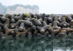 8. The shape and materials (tetrapods or similar) of the satellite harbour: These mimic the lunate islet structure in (6) and attenuate (wear down) wave energy in 3 main ways:
- Direct wave attenuation at the tetrapods through waves breaking on their roughness, destroying the organisation of the wave form
- Waves that do bounce back out (will be minimal) will also fan out like the lines shown inside the satellite harbour, but in mirror image. That means the reflected waves will spread what energy they had over a larger area than they originally came in on
- Energy will also be translated along the satellite harbour wall on the outside (arrows) which can withstand and distribute the load just like a building arch.
9. The tetrapods will not stop waves dead in their tracks like a straight concrete wall, but allow water to move through the wall and act as a wave dissipater. In places where these have been used (e.g. Maldives) the free water movements also mean that water quality in the harbour remains high.
Examples of harbours that show these Elements in Action
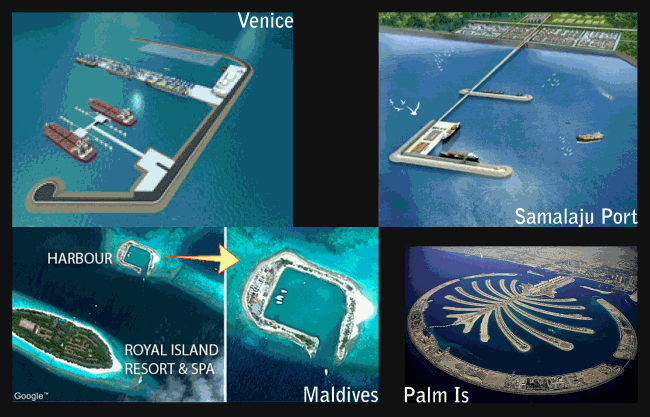
There are many examples of harbours around the world either already constructed or on the way that include the elements of this design. Here are some, though some of the straight walls miss the benefits of the lunate or arch structure (straight walls being a feature I would not use on atolls). Offshore structures are seen as state-of-the-art with significant benefits.
Talking about the new Venice (Italy) Harbour development, Captain Antonio Revedin, Director Strategic Planning and Development at the Venice Port Authority, commented:
“The implemented design of the onshore-offshore terminal and the water transfer system have displayed performance results that easily match and even surpass those of the best container terminals in the whole world. Along with making these significant expenditure cuts, the manner in which the terminal itself will operate will generate quite a long list of benefits…”
Image: Port concepts and structures in Venice (Italy), Samalaju Port, Bintulu (Malaysia), Royal Island (Maldives), Palm Island (Dubai).
Sources
Webb, A.P., Kench, P.S. (2010) The dynamic response of reef islands to sea-level rise: Evidence from multi-decadal analysis of island change in the Central Pacific, Global and Planetary Change (2010), doi:10.1016/j.gloplacha.2010.05.003.

