Tsunami threat passes after magnitude-7.5 earthquake strikes near Papua New Guinea, officials say
 The threat of a tsunami has largely passed after a magnitude-7.5 earthquake struck off Papua New Guinea, official monitors say.
The quake — initially estimated at magnitude-7.7 — hit at a depth of 33 kilometres.
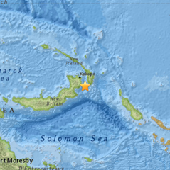
The epicentre was 54 kilometres from the nearest city of Kokopo Panguna on New Britain island and 789 kilometres from the capital Port Moresby, the United States Geological Survey (USGS) said.
The Pacific Tsunami Warning Centre in Hawaii said minor sea level fluctuations of up to 30 centimetres above normal tides were still expected over the next few hours.
“Based on all data available … the tsunami threat from this earthquake has now mostly passed,” the centre said in a statement.
Mika Tuvi, an employee at the Rabaul Hotel near Kokopo, told the ABC the ground shook strongly for about five minutes but there did not appear to be any major damage.
“We were scared. We thought that the building might collapse,” she said.
The Global Disaster Alert and Coordination System said wave peaks of 50 centimetres were recorded in locations close to the epicentre two minutes after the quake struck.
The initial quake was also followed by a smaller magnitude-5.7 aftershock in the same area.
PNG National Disaster Centre acting director Martin Mosa said there had been no reports of damage recorded from the central and northern parts of New Ireland province.
“At this point in time, I can maintain with confidence that we hope that nothing of greater magnitude or destruction has been recorded,” he told the ABC.
“We will be trying to contact our Rabaul operations observatory [to check] if they are able to confirm with us if there was any tsunami being experienced around the area.”
The Pacific Tsunami Warning Centre said said no destructive, Pacific-wide tsunami was expected but waves reaching one to three metres above the tide level were possible along some coasts of Papua New Guinea and Solomon Islands.
The waves were forecast to be less than 30 centimetres above the tide level for the coasts of Australia, Japan, Philippines, New Caledonia, Northern Marianas, Guam, Palau, Yap, Pohnpei, Chuuk, Kosrae, Marshall Islands, Fiji, Samoa, American Samoa, Cook Islands, Tokelau, Vanuatu, Kiribati, Nauru, Wake Island, Johnston Island, Howland and Baker, Tonga, Tuvalu, Wallis and Futuna, Solomon Islands, Indonesia and NW Hawaiian Islands.
“Persons located in threatened coastal areas should stay alert for information and follow instructions from national and local authorities,” the centre added.
Earthquakes are common in PNG, which sits on the so-called Pacific Ring of Fire, a hotspot for seismic activity due to friction between tectonic plates.
“The earthquake this morning was a tectonic event, in an area that’s well established as tectonically very active,” Port Moresby geophysical observatory assistant director Chris McKee said.
The last big tremor off the Pacific nation’s coast was a magnitude-6.8 quake that struck Bougainville island in December.
ABC/wires http://www.abc.net.au/news/2015-03-30/magnitude-77-earthquake-strikes-near-papua-new-guinea/6358262
Magnitude 7.7 earthquake strikes near Papua New Guinea; tsunami warning issued
 A major earthquake with a magnitude of 7.7 struck off Papua New Guinea, official monitors said, and a tsunami warning was issued soon after.
The quake hit at a depth of 65 kilometres, some 54 kilometres from the nearest city of Kokopo Panguna on New Britain island and 789 kilometres from the capital Port Moresby, the United States Geological Survey (USGS) said.
An employee at the Rabaul Hotel, near Kokopo, told the ABC the ground shook strongly for about five minutes but there does not appear to be any major damage.
The Global Disaster Alert and Coordination System said wave peaks of 50 centimetres were recorded in locations close to the epicentre two minutes after the quake struck.
The initial quake was also followed by a smaller 5.7-magnitude aftershock in the same area.
PNG National Disaster Centre acting director Martin Mosa said there had been no reports of damage recorded from the central and northern parts of New Ireland province.
“We have already been in touch with our provincial disaster authorities there … they are having difficulty getting through to some districts because communication is down,” he told the ABC.
“At this point in time, I can maintain with confidence that we hope that nothing of greater magnitude or destruction has been recorded.
“We will be trying to contact our Raboul operations observatory if they are able to confirm with us if there was any tsunami being experienced around the area.”
The Pacific Tsunami Warning Centre in Hawaii said “based on preliminary earthquake parameters … hazardous tsunami waves are possible for coasts located within 1,000 kilometres of the earthquake epicentre along the coasts of Papua New Guinea and the Solomon Islands”.
It said no destructive, Pacific-wide tsunami was expected but waves reaching 1 to 3 metres above the tide level were possible along some coasts of Papua New Guinea.
Any tsunami risk was expected to be limited to PNG and the Solomon Islands.
The waves are forecast to be less than 30 centimetres above the tide level for the coasts of Australia, Japan, Philippines, New Caledonia, Northern Marianas, Guam, Palau, Yap, Pohnpei, Chuuk, Kosrae, Marshall Islands, Fiji, Samoa, American Samoa, Cook Islands, Tokelau, Vanuatu, Kiribati, Nauru, Wake Island, Johnston Island, Howland and Baker, Tonga, Tuvalu, Wallis and Futuna, Solomon Islands, Indonesia and NW Hawaiian Islands.
“Persons located in threatened coastal areas should stay alert for information and follow instructions from national and local authorities,” the centre added.
Earthquakes are common in PNG, which sits on the so-called Pacific Ring of Fire, a hotspot for seismic activity due to friction between tectonic plates.
The last big tremor off the Pacific nation’s coast was a 6.8-magnitude quake that struck Bougainville island in December.
ABC/wires (Source: ABC News; March 30, 2015; http://tinyurl.com/pp8bl6m)
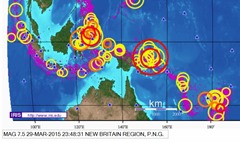
Earthquake: M7.5 – 55km SE of Kokopo, PNG
 Event Location: 4.760°S 152.556°E depth=40.0 km
Data Source: US3; Event Time 2015-03-29 23:48:31 (UTC)
2015-03-30 09:48:31 (UTC+10:00) in your timezone
- Nearby Cities 55km (34mi) SE of Kokopo, Papua New Guinea
; 281km (175mi) ENE of Kimbe, Papua New Guinea
; 310km (193mi) SE of Kavieng, Papua New Guinea
; 367km (228mi) WNW of Arawa, Papua New Guinea
; 787km (489mi) NE of Port Moresby, Papua New Guinea
Tectonic Summary: Seismotectonics of the New Guinea Region and Vicinity
The Australia-Pacific plate boundary is over 4000 km long on the northern margin, from the Sunda (Java) trench in the west to the Solomon Islands in the east. The eastern section is over 2300 km long, extending west from northeast of the Australian continent and the Coral Sea until it intersects the east coast of Papua New Guinea. The boundary is dominated by the general northward subduction of the Australia plate.
Along the South Solomon trench, the Australia plate converges with the Pacific plate at a rate of approximately 95 mm/yr towards the east-northeast. Seismicity along the trench is dominantly related to subduction tectonics and large earthquakes are common: there have been 13 M7.5+ earthquakes recorded since 1900. On April 1, 2007, a M8.1 interplate megathrust earthquake occurred at the western end of the trench, generating a tsunami and killing at least 40 people. This was the third M8.1 megathrust event associated with this subduction zone in the past century; the other two occurred in 1939 and 1977.
Further east at the New Britain trench, the relative motions of several microplates surrounding the Australia-Pacific boundary, including north-south oriented seafloor spreading in the Woodlark Basin south of the Solomon Islands, maintain the general northward subduction of Australia-affiliated lithosphere beneath Pacific-affiliated lithosphere. Most of the large and great earthquakes east of New Guinea are related to this subduction; such earthquakes are particularly concentrated at the cusp of the trench south of New Ireland. 33 M7.5+ earthquakes have been recorded since 1900, including three shallow thrust fault M8.1 events in 1906, 1919, and 2007.
The western end of the Australia-Pacific plate boundary is perhaps the most complex portion of this boundary, extending 2000 km from Indonesia and the Banda Sea to eastern New Guinea. The boundary is dominantly convergent along an arc-continent collision segment spanning the width of New Guinea, but the regions near the edges of the impinging Australia continental margin also include relatively short segments of extensional, strike-slip and convergent deformation. The dominant convergence is accommodated by shortening and uplift across a 250-350 km-wide band of northern New Guinea, as well as by slow southward-verging subduction of the Pacific plate north of New Guinea at the New Guinea trench. Here, the Australia-Pacific plate relative velocity is approximately 110 mm/yr towards the northeast, leading to the 2-8 mm/yr uplift of the New Guinea Highlands.
Whereas the northern band of deformation is relatively diffuse east of the Indonesia-Papua New Guinea border, in western New Guinea there are at least two small (<100,000 km²) blocks of relatively undeformed lithosphere. The westernmost of these is the Birds Head Peninsula microplate in Indonesia’s West Papua province, bounded on the south by the Seram trench. The Seram trench was originally interpreted as an extreme bend in the Sunda subduction zone, but is now thought to represent a southward-verging subduction zone between Birds Head and the Banda Sea.
There have been 22 M7.5+ earthquakes recorded in the New Guinea region since 1900. The dominant earthquake mechanisms are thrust and strike slip, associated with the arc-continent collision and the relative motions between numerous local microplates. The largest earthquake in the region was a M8.2 shallow thrust fault event in the northern Papua province of Indonesia that killed 166 people in 1996.
The western portion of the northern Australia plate boundary extends approximately 4800 km from New Guinea to Sumatra and primarily separates Australia from the Eurasia plate, including the Sunda block. This portion is dominantly convergent and includes subduction at the Sunda (Java) trench, and a young arc-continent collision.
In the east, this boundary extends from the Kai Islands to Sumba along the Timor trough, offset from the Sunda trench by 250 km south of Sumba. Contrary to earlier tectonic models in which this trough was interpreted as a subduction feature continuous with the Sunda subduction zone, it is now thought to represent a subsiding deformational feature related to the collision of the Australia plate continental margin and the volcanic arc of the Eurasia plate, initiating in the last 5-8 Myr. Before collision began, the Sunda subduction zone extended eastward to at least the Kai Islands, evidenced by the presence of a northward-dipping zone of seismicity beneath Timor Leste. A more detailed examination of the seismic zone along it’s eastern segment reveals a gap in intermediate depth seismicity under Timor and seismic mechanisms that indicate an eastward propagating tear in the descending slab as the negatively buoyant oceanic lithosphere detaches from positively buoyant continental lithosphere. On the surface, GPS measurements indicate that the region around Timor is currently no longer connected to the Eurasia plate, but instead is moving at nearly the same velocity as the Australia plate, another consequence of collision.
Large earthquakes in eastern Indonesia occur frequently but interplate megathrust events related to subduction are rare; this is likely due to the disconnection of the descending oceanic slab from the continental margin. There have been 9 M7.5+ earthquakes recorded from the Kai Islands to Sumba since 1900. The largest was the great Banda Sea earthquake of 1938 (M8.5) an intermediate depth thrust faulting event that did not cause significant loss of life.
(Source: USGS; March 30, 2015; http://tinyurl.com/ns37gds)
